ADO project - Hydrological datasets
The database contains observational daily discharge and water level data deriving from the first measurement (which differs for each region) to the present, with more than 1400 stations. These datasets were collected from multiple data providers within the ADO study region, covering the countries Austria, France, Germany, Italy, Slovenia, and Switzerland. The spanned period is 1869-2021. For some regions in Italy there are records to 2022. The missing data were added to have a continuous time series.
Data sources
The datasets come from the following sources:
- Austrian stations were used from the HISTALP project from ZAMG.
- Discharge data for France were extracted by INRAE RiverLy from the French HYDRO database (http://www.hydro.eaufrance.fr/).
- Bayerisches Landesamt Für Umwelt for the Bayern region (https://www.gkd.bayern.de/).
- Slovenia stations were downloaded from the Arso website (http://www.arso.gov.si/vode/podatki/).
- Switzerland: from Bundesamt für Umwelt BAFU Hydroligsche Daten.
- Italy stations comes from:
- Valle d’Aosta: from Centro Funzionale regione autonoma Valle d’Aosta
- Lombardia: provided from Arpa Lombardia
- Liguria: provided from Arpa Liguria
- Piemonte: Banca dati idrologici from Arpa Piemonte
- Friuli Venezia: from Arpa Friuli Venezia
- Trentino: from provincial autonoma di Trento
- Veneto: from Arpa Veneto
- South Tyrol: WISKI database
- Emilia Romagna: Arpae - Struttura idro-Meteo-Clima
Tables description
The database climate data contains the schema Hydrology in which it is possible to find the hydrological datasets collected within the Alpine region. This schema contains five tables which will be described below:
1.discharge: daily time-series of discharge stations present within the ADO space, obtained from different providers. Is made up of four columns: id station, date, discharge and the data quality information given by its different providers. For a total of 1436 stations.
2.metadata_discharge: information for each station site (id_station, country, region, site location, coordinates, start date, end date, watercourse, altitude, catchment area, etc.)
- id_station: Unique for each station, as mentioned above.
- Countries: Austria, France, Germany, Italy, Slovenia and Switzerland.
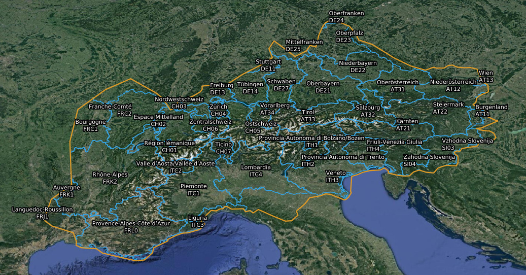
- Regions: the regions present within the ADO area are shown in the following image.
All the stations have a record length greater than 10 years, except for Slovenia and the Italian regions Liguria and Friuli Venezia Giulia.
3.Water_level: daily time series of water level stations located within the ADO space, obtained from different providers. Is made up of four columns: id station, date, water_level, and data quality information given by its different providers. For a total of 936 stations.
4.Metadata_wtl: information for each of the water level stations (id_station, country, region, site location, coordinates, start date, end date, watercourse, altitude, catchment area, etc.)
5.catchment_area: information about the catchment area for each gauging station. This information is obtained with a simple algorithm that retrieves the upstream catchment area from the CCM2 hydrological dataset. It can be found here. A description of the latter is available here The geometrical field contains the polygon with the catchment area. The CRS is WGS84 (EPSG:4326).
The ML_discharge schema contains predictions produced with the Support Vector Regressors approach. Code and description are available here. The tables are:
- mod_disc: this table contains the date, the modeled monthly averaged discharge, and the availability of a discharge measurement on the schema Hydrology. The modeled discharge is estimated when the ERA-5 reanalysis and the Snow-grid data are released, hence with a few days of delay.
- pred_disch: this table contains the date, and monthly averaged discharge prediction with 10 and 20 days of advance. For producing the prediction with a lead time, reanalyzed meteorological and snow variables are substituted with their climatology.
Web Map Service
Stations location is visibile by a spatial layer that can be accessed by a GIS client (or R) to compose maps using the WMS service: https://maps.eurac.edu/geoserver/ows?service=WMS&version=1.1.1&request=GetCapabilities, use the keyword "ado" to filter layer list. A preview of the station coverage is provided here below or opening this MAP. Using this tool it is possible to query the features to get stations metadata.
Contacts
If you have any scientific questions, please contact:
For technical support about this documentation, please contact: