 EDP metadata catalog
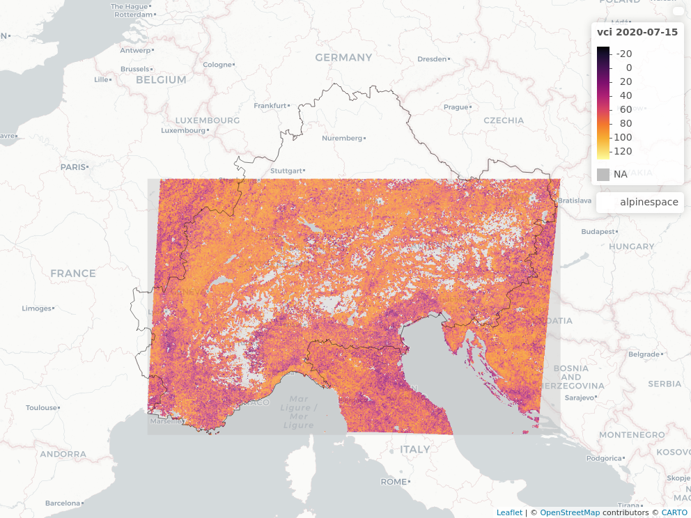
Vegetation Condition Index - 231 m 8 days
The Vegetation Condition Index (VCI) is based on the Normalized Difference Vegetation Index (NDVI) derived from MODIS satellite data. The NDVI is based on 8 day maximum value composite MOD09Q1 (v006) reflectance products. The spatial resolution is 231 m. The NDVI is masked to the highest quality standards using the provided quality layers. Missing pixel values in the time series are linearly interpolated. Non-vegetated areas are masked using the most recent Corine Land Cover product version for the according year. The final product is regridded to the LAEA Projection (EPSG:3035). The VCI is calculated using the formula VCIi = (NDVIi - NDVImin,i)/(NDVImax,i - NDVImin,i) * 100. The VCI expresses anomalies of the NDVI. The data is provided as 8 day measures. The time series is starting from 2001. The VCI values range from 0-100, whereas high values correspond to healthy vegetation and low values indicate stressed vegetation.
Simple
Identification info
- Alternate title
-
ADO_VCI_MODIS_231m_3035
- Date (Creation)
- 2024-10-01T09:51:04
- Date (Publication)
- 2024-10-01T09:51:04
- Edition
-
v1
- Citation identifier
- https://openeo.eurac.edu/collections/ADO_VCI_MODIS_231m_3035/publisher
- Presentation form
- Digital map
- Purpose
-
Michele Meroni, Dominique Fasbender, Felix Rembold, Clement Atzberger, Anja Klisch: Near real-time vegetation anomaly detection with MODIS NDVI: Timeliness vs. accuracy and effect of anomaly computation options, Remote Sensing of Environment, Volume 221, 2019, Pages 508-521, ISSN 0034-4257, https://doi.org/10.1016/j.rse.2018.11.041, ( https://www.sciencedirect.com/science/article/pii/S0034425718305509)
- Status
- On going
- Point of contact
-
Role Organisation Electronic mail address Custodian Eurac Research - Institute for Earth Observation
- Spatial representation type
- Grid
- Topic category
-
- Imagery base maps earth cover
Extent
Temporal extent
- Time period
- 2001-01-01T00:00:00Z 2022-08-29T00:00:00Z
Extent
))
- Maintenance and update frequency
- As needed
- GEMET - INSPIRE themes, version 1.0
-
-
Land use
-
Land cover
-
- Product
-
-
collection
-
vegetation condition index
-
vci
-
modis
-
ADO project
-
ADO
-
- Platform
-
-
Terra
-
Resource constraints
- Use limitation
-
CC BY 4.0
- Access constraints
- Other restrictions
- Other constraints
-
CC BY 4.0
- Supplemental Information
-
Additional information can be added here
Content Information
- Attribute description
- Minimum value for cloud coverage
- Cloud cover percentage
- 0.0
Content Information
- Attribute description
- Maximum value for cloud coverage
- Cloud cover percentage
- 0.0
Content Information
- Attribute description
- Band: 8d_vci
- Content type
- Auxillary Information
- Description
-
Mean wavelength value for the 8d_vci band
- Maximum value
- 0
- Minimum value
- 0
- Identifier
- https://www.bipm.org/en/measurement-units/
- Name
- nanometer
Distribution Information
- Distribution format
-
-
WCS
-
- Distributor contact
-
Role Organisation Electronic mail address Publisher Institute for Earth Observation
- OnLine resource
-
ADO_VCI_MODIS_231m_3035
Open Application Programming Interface for Earth Observation. More information here: https://openeo.org/documentation/1.0/developers/
OnLine resource
- Website
-
Digital Object Identifier (DOI)
Zellner, P., & Castelli, M. (2022). Vegetation Condition Index - 231 m 8 days (Version 1.0) [Data set]. Eurac Research. https://doi.org/10.48784/16367c6a-534a-11ec-b0a3-02000a08f41d
- OnLine resource
-
Digital Object Identifier (DOI)
Zellner, P., & Castelli, M. (2022). Vegetation Condition Index - 231 m 8 days (Version 1.0) [Data set]. Eurac Research. https://doi.org/10.48784/16367c6a-534a-11ec-b0a3-02000a08f41d
Data quality info
- Hierarchy level
- Dataset
Report
- Measure identification
- INSPIRE/Conformity_001
Result
- Title
-
COMMISSION REGULATION (EU) No 1089/2010 of 23 November 2010 implementing Directive 2007/2/EC of the European Parliament and of the Council as regards interoperability of spatial data sets and services
- Explanation
-
See technical references
Resource lineage
- Statement
-
Not Available
- Hierarchy level
- Dataset
Spatial representation info
- Number of dimensions
- 2
- Dimension name
- Row
- Resolution
- 0.0 m
- Dimension description
-
dims description
- Dimension name
- Column
- Resolution
- 0.0
- Dimension description
-
dims description
- Cell geometry
- Area
- Transformation parameter availability
- false
Reference System Information
- Reference system identifier
- EPSG/3035
- Reference system type
- Projected
- Hierarchy level
- Collection hardware
Instrument
- Title
-
MODIS
- Description
-
Text description of the instrument (if necessary)
Platform
- Sponsor
-
Role Organisation Electronic mail address Funder European Space Agency - Copernicus program
- Maintenance and update frequency
- As needed
Metadata
- Metadata identifier
- urn:uuid/9f7fc52e-23ce-11ef-9957-8d8b4d692a59
- Language
- English
- Character encoding
- UTF8
- Contact
-
Role Organisation Electronic mail address Point of contact Eurac Research - Institute for Earth Observation
Type of resource
- Resource scope
- Dataset
- Date info (Revision)
- 2025-09-11T09:24:52Z
- Date info (Creation)
- 2024-10-01T09:51:04
Metadata standard
- Title
-
ISO 19115-3
Overviews
Spatial extent
Provided by