 EDP metadata catalog
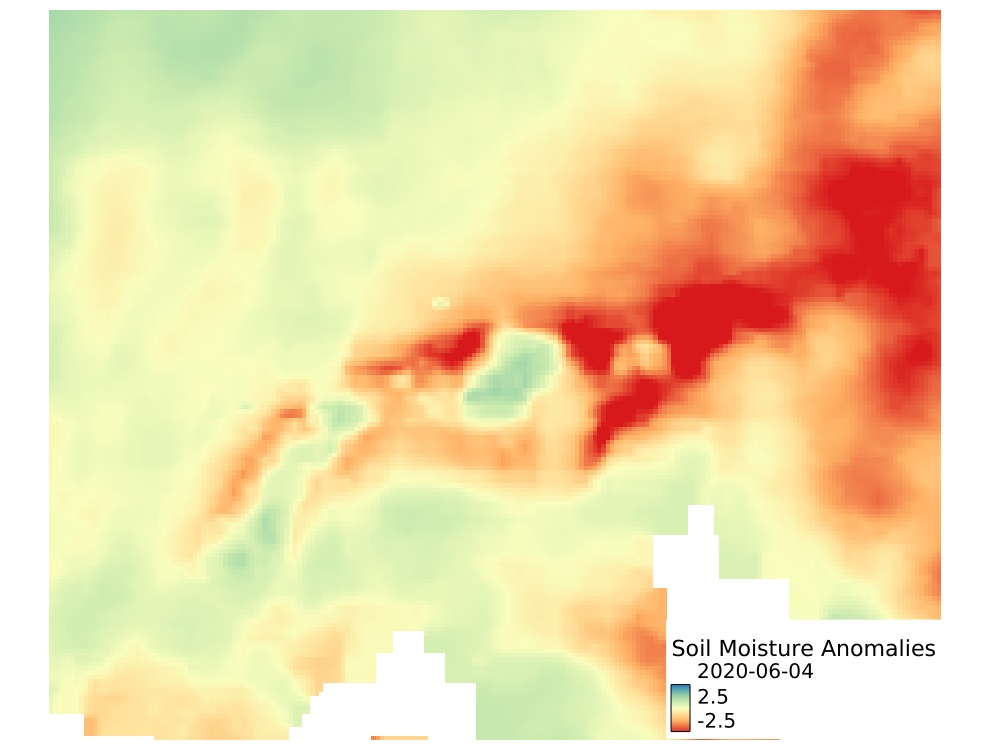
Soil Moisture Anomalies - ERA5_QM
The Soil Moisture Anomaly is a drought indicator used to detect and monitor agricultural drought conditions, defined by a prolonged period of deficit in the availability of soil moisture to plants. The soil moisture anomalies provided as part of the Alpine Drought Observatory was derived from ERA5 Volumetric Soil Water Layers at different depths with Layer 1 (0-7cm), Layer 2 (7-28cm), Layer 3 (28–100cm), and Layer 4 (100-289cm). The input ERA5 soil moisture dataset was downscaled using a quantile mapping approach. Daily anomalies were calculated using a climatological mean and standard deviation of soil moisture from a smoothed time-series (running mean on a 10-day window) for a reference period of 1981–2020. The Soil Moisture Anomalies values range from -5 to +5, with negative values indicating drier than conditions while positive values indicate wetter than normal conditions, and -1 to +1 values indicates near-normal conditions. Datasets contains modified Copernicus Climate Change Service Information [1980–current year]; contains modified Copernicus Atmosphere Monitoring Service Information [1980-current year]. Neither the European Commission nor ECMWF is responsible for any use that may be made of the Copernicus information or data it contains.
Simple
Identification info
- Alternate title
-
ADO_SM_anomalies_ERA5
- Date (Creation)
- 2024-10-01T09:51:26
- Date (Publication)
- 2024-10-01T09:51:26
- Edition
-
v1
- Citation identifier
- https://openeo.eurac.edu/collections/ADO_SM_anomalies_ERA5/publisher
- Presentation form
- Digital map
- Purpose
-
Hersbach, H., Bell, B., Berrisford, P., Biavati, G., Horányi, A., Muñoz Sabater, J., Nicolas, J., Peubey, C., Radu, R., Rozum, I., Schepers, D., Simmons, A., Soci, C., Dee, D., Thépaut, J-N. (2018): ERA5 hourly data on single levels from 1979 to present. Copernicus Climate Change Service (C3S) Climate Data Store (CDS). (Accessed on < 10-May-2021 >), 10.24381/cds.adbb2d47
- Status
- On going
- Point of contact
-
Role Organisation Electronic mail address Custodian Eurac Research - Institute for Earth Observation
- Spatial representation type
- Grid
- Topic category
-
- Imagery base maps earth cover
Extent
Temporal extent
- Time period
- 1979-12-31T12:00:00Z 2024-05-27T12:00:00Z
Extent
))
- Maintenance and update frequency
- As needed
- GEMET - INSPIRE themes, version 1.0
-
-
Land use
-
Land cover
-
- Product
-
-
collection
-
Soil Moisture
-
Alpine Drought Observatory
-
Soil Moisture Anomalies
-
ERA5
-
Collection
-
ADO project
-
ADO
-
cct
-
- Platform
-
-
N/A
-
Resource constraints
- Use limitation
-
CC BY 4.0
- Access constraints
- Other restrictions
- Other constraints
-
CC BY 4.0
- Supplemental Information
-
Additional information can be added here
Content Information
- Attribute description
- Minimum value for cloud coverage
- Cloud cover percentage
- 0.0
Content Information
- Attribute description
- Maximum value for cloud coverage
- Cloud cover percentage
- 0.0
Content Information
- Attribute description
- Band: swvl1
- Content type
- Auxillary Information
- Description
-
Mean wavelength value for the swvl1 band
- Maximum value
- 0
- Minimum value
- 0
- Identifier
- https://www.bipm.org/en/measurement-units/
- Name
- nanometer
Content Information
- Attribute description
- Band: swvl2
- Content type
- Auxillary Information
- Description
-
Mean wavelength value for the swvl2 band
- Maximum value
- 0
- Minimum value
- 0
- Identifier
- https://www.bipm.org/en/measurement-units/
- Name
- nanometer
Content Information
- Attribute description
- Band: swvl3
- Content type
- Auxillary Information
- Description
-
Mean wavelength value for the swvl3 band
- Maximum value
- 0
- Minimum value
- 0
- Identifier
- https://www.bipm.org/en/measurement-units/
- Name
- nanometer
Content Information
- Attribute description
- Band: swvl4
- Content type
- Auxillary Information
- Description
-
Mean wavelength value for the swvl4 band
- Maximum value
- 0
- Minimum value
- 0
- Identifier
- https://www.bipm.org/en/measurement-units/
- Name
- nanometer
Distribution Information
- Distribution format
-
-
WCS
-
- Distributor contact
-
Role Organisation Electronic mail address Publisher Institute for Earth Observation
- OnLine resource
-
ADO_SM_anomalies_ERA5
Open Application Programming Interface for Earth Observation. More information here: https://openeo.org/documentation/1.0/developers/
OnLine resource
- Website
-
Digital Object Identifier (DOI)
Greifeneder, F., & Balogun, R. (2022). Soil Moisture Anomalies - ERA5_QM (Version v2) [Data set]. Institute for Earth Observation. https://doi.org/10.48784/ea665ca2-0ceb-11ed-86c5-02000a08f4e5
- OnLine resource
-
Digital Object Identifier (DOI)
Greifeneder, F., & Balogun, R. (2022). Soil Moisture Anomalies - ERA5_QM (Version v2) [Data set]. Institute for Earth Observation. https://doi.org/10.48784/ea665ca2-0ceb-11ed-86c5-02000a08f4e5
Data quality info
- Hierarchy level
- Dataset
Report
- Measure identification
- INSPIRE/Conformity_001
Result
- Title
-
COMMISSION REGULATION (EU) No 1089/2010 of 23 November 2010 implementing Directive 2007/2/EC of the European Parliament and of the Council as regards interoperability of spatial data sets and services
- Explanation
-
See technical references
Resource lineage
- Statement
-
Not Available
- Hierarchy level
- Dataset
Spatial representation info
- Number of dimensions
- 2
- Dimension name
- Row
- Resolution
- 0.0 m
- Dimension description
-
dims description
- Dimension name
- Column
- Resolution
- 0.0
- Dimension description
-
dims description
- Cell geometry
- Area
- Transformation parameter availability
- false
Reference System Information
- Reference system identifier
- EPSG/3035
- Reference system type
- Projected
- Hierarchy level
- Collection hardware
Instrument
- Title
-
N/A
- Description
-
Text description of the instrument (if necessary)
Platform
- Sponsor
-
Role Organisation Electronic mail address Funder European Space Agency - Copernicus program
- Maintenance and update frequency
- As needed
Metadata
- Metadata identifier
- urn:uuid/8325413c-23e8-11ef-9957-8d8b4d692a59
- Language
- English
- Character encoding
- UTF8
- Contact
-
Role Organisation Electronic mail address Point of contact Eurac Research - Institute for Earth Observation
Type of resource
- Resource scope
- Dataset
- Date info (Revision)
- 2025-09-11T09:24:52Z
- Date info (Creation)
- 2024-10-01T09:51:26
Metadata standard
- Title
-
ISO 19115-3
Overviews
Spatial extent
Provided by