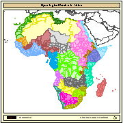
Major hydrological basins and their sub-basins. This dataset divides the African continent according to its hydrological characteristics. The dataset consists of the following information:- numerical code and name of the major basin (MAJ_BAS and MAJ_NAME); - area of the major basin in square km (MAJ_AREA); - numerical code and name of the sub-basin (SUB_BAS and SUB_NAME); - area of the sub-basin in square km (SUB_AREA); - numerical code of the sub-basin towards which the sub-basin flows (TO_SUBBAS) (the codes -888 and -999 have been assigned respectively to internal sub-basins and to sub-basins draining into the sea)
Africa, watersheds, river basins, water resources, hydrology, AQUASTAT, AWRD
| FAO - NRCW |
| jippe.hoogeveen@fao.org |
| Viale delle Terme di Caracalla, Rome, 00153, Italy |


2006-01-01T04:29:00  2008-01-08T04:29:00
WGS 1984 (WGS 1984:)
Vector
Inland waters
| Name | Description | Link | Date published | Category |
|---|---|---|---|---|
| Maps web services URLs | Here you can find all the available web service URLs provided by Maps, to consume datasets through an interoperable client (QGIS, Python, etc.) or to develop codes for analysis. The most relevant services to access datasets are: WMS (Web Map Service) to visualize layers in a map and to query them); WFS (Web Feature Service) or WCS (Web Coverage Service) to download raw datsets and use them for deep analysis or transformation. | Link | Dec. 13, 2021 | Maps |
| maps.eurac.edu documentation | maps.eurac.edu is based on Geonode, here the link to the official documentation | Link | April 28, 2021 | Maps |